Welcome to the Virtual Education Wiki ~ Open Education Wiki
File:268px-Belgium provinces regions striped.png
Jump to navigation
Jump to search
No higher resolution available.
268px-Belgium_provinces_regions_striped.png (268 × 219 pixels, file size: 20 KB, MIME type: image/png)
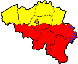
Map of Belgium showing the provinces (black lines) and regions (colours). Yellow = Flanders, Red = Wallonia, Blue = German-speaking part, Orange = Brussels Capital Region.
Original png on: http://en.wikipedia.org/wiki/Image:Belgium_provinces_regions_striped.png
File history
Click on a date/time to view the file as it appeared at that time.
| Date/Time | Thumbnail | Dimensions | User | Comment | |
|---|---|---|---|---|---|
| current | 12:44, 5 May 2008 | | 268 × 219 (20 KB) | NikkiCortoos (talk | contribs) | Map of Belgium showing the provinces (black lines) and regions (colours). Yellow = Flanders, Red = Wallonia, Blue = German-speaking part, Orange = Brussels Capital Region. Original png on: http://en.wikipedia.org/wiki/Image:Belgium_provinces_regions_stri |
You cannot overwrite this file.